
Precise
Room and floor, with mapped local X/Y/Z or sub-zone context where supported.
Typical sourceValidated LiveLocate or LivePoint deployment, fixed registered endpoint, or approved indoor provider.SOS LiveLocate + LiveGrid
LiveLocate is the indoor positioning engine. LiveGrid turns its best supported result into responder-ready floor, room, zone, route, confidence, source, and movement context.

A location is more than a pin
GPS can bring a responder to an address. Inside a complex facility, the useful question is often: which building, floor, wing, room, deck, or corridor—and how certain is that answer right now?
Room and floor, with mapped local X/Y/Z or sub-zone context where supported.
Typical sourceValidated LiveLocate or LivePoint deployment, fixed registered endpoint, or approved indoor provider.Quadrant, wing, unit, corridor, deck, sector, or another mapped operational zone.
Typical sourceModerate-confidence signal fingerprint, trajectory-constrained result, or partner provider.The identified structure within a campus or property when finer indoor evidence is unavailable.
Typical sourceSite presence, registered gateway, coarse indoor provider, or graceful degradation.Latitude and longitude with accuracy, source, and age attached.
Typical sourceSOS Aegis operating-system GNSS or network location, or an approved partner source.If confidence drops, SOS Live broadens the displayed location from room to zone or building rather than continuing to show a stale room label.
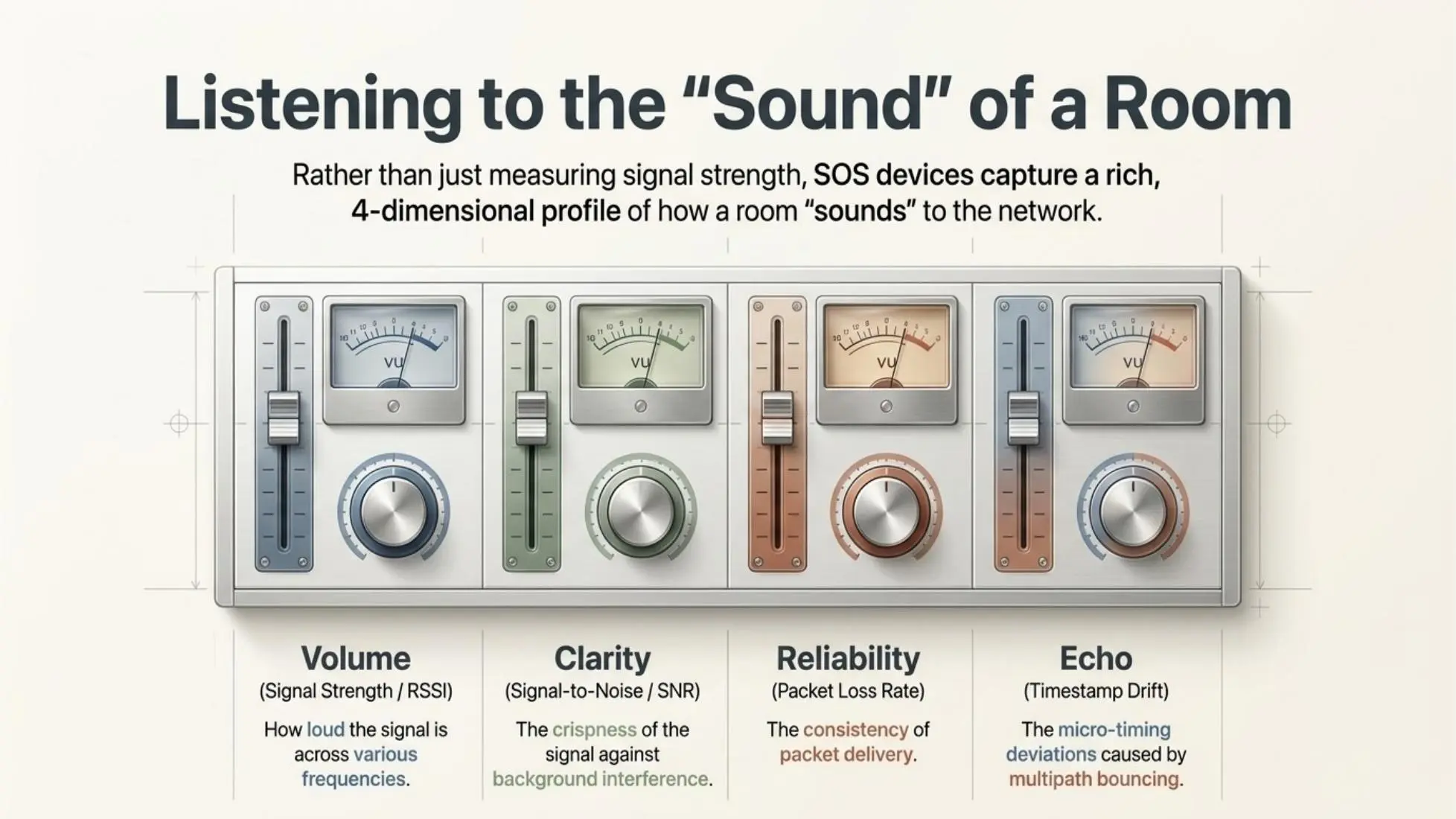
A different model for indoor location
In supported deployments, LiveLocate is designed to recognize how sub-GHz signals interact with a physical space. Instead of relying only on estimated distance, it compares a multi-dimensional signal fingerprint associated with a mapped zone.
Received signal strength across the participating configuration.
Signal-to-noise behavior against the local RF environment.
Packet delivery consistency across the participating network.
Micro-timing variation influenced by multipath reflections.
From survey to recognition
LiveLocate profiles mapped zones, compares active observations against approved signal models, applies confidence and physical constraints, and publishes the selected semantic location to LiveGrid.

Movement that respects the building
LiveLocate uses mapped doors, corridors, stairs, elevators, rooms, and floors to understand valid movement. A transient match that violates the physical path can be rejected or down-weighted instead of becoming a misleading location jump.

Time-ordered locations follow valid transitions through the mapped environment.
Participating nodes evaluate signal quality and assume appropriate observer or transmitter roles.
When a node changes or fails, another can assume the active role without manual reconfiguration.
The alert still routes while the displayed precision broadens to match available evidence.
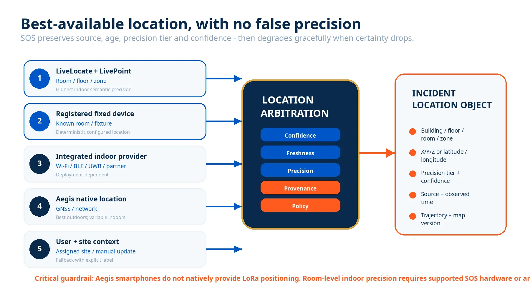
Best-available source
SOS Live can receive location from LiveLocate, registered devices, indoor partners, SOS Aegis, and authorized user context. It selects one operational location using policy, precision, confidence, freshness, and source health—while retaining alternate or conflicting observations for audit.
Build a better response
We’ll review your buildings, materials, floorplans, movement patterns, response roles, and required precision tiers to design an evidence-based LiveLocate evaluation.